PART III - CASE STUDY 4.3
Zonal development on the coast of northeast Wales
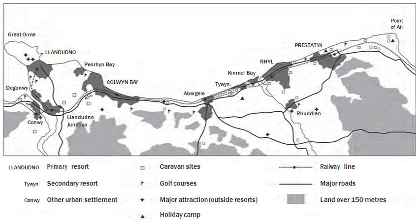
The primary tourism zone on the coast of north-east Wales extends for some 45km from Point of Air in the east to the Great Orme and Conwy Estuary in the west. Except for an area of more extended lowland around the estuary of the River Clwyd, development has generally been confined to a narrow coastal strip of often no more than 1–2km in width. The southern fringes of this coastal zone are mostly defined by areas of higher ground that quickly attain heights in excess of 200m and which tend to slope steeply towards the sea, providing a significant barrier to urban encroachment.
Tourism development in this region dates from the middle of the nineteenth century. Although steamer services from Liverpool had helped to establish a modest excursion trade to destinations such as Prestatyn during the 1830s, it was the arrival of the Chester and Holyhead Railway in 1848 that enabled the development of a string of new Victorian resorts at Llandudno, Colwyn Bay and Rhyl (see Figure 1). Prior to their emergence as resorts, each of these places comprised little more than a handful of dwellings but under the growing levels of demand from the industrial regions in north-west England, each had become established as a primary coastal resort by the start of the twentieth century with – by local standards – a sizeable permanent population of around 9,000 people each. Alongside the development of these major resorts, a secondary string of smaller tourism places also emerged – often through a ‘spill-over’ effect – including Kinmel Bay, Tywyn, Abergele, Rhos-on-Sea and Penrhyn Bay, helping to create a semi-continuous zone of urban coastal tourism along the route of the main railway line and the main (A55) coast road.
Subsequent development has served to emphasise the linear qualities of this tourism zone. After 1945, the more-easily developed coastal areas between Abergele and Prestatyn proved to be an attractive location for the development of both permanent and touring caravan sites and, on a more limited basis, holiday camps. Tywyn, in particular, has seen significant development of caravan sites, but as Figure 1 illustrates, caravanning is ubiquitous across the region. The impact of these developments – when combined with the parallel development of other tourism amenities (such as golf courses) and the more recent integration of a widening range of heritage and commercial attractions into the framework of tourism in the region – has been to trigger a significant level of in-filling around the older resorts. The composite effect of these different phases of development has been to produce a distinctive zone of tourism that dominates the landscape of this coastal region of the UK.
Figure 1. Patterns of tourism development on the north coast of Wales
Zonal development on the coast of northeast Wales
The primary tourism zone on the coast of north-east Wales extends for some 45km from Point of Air in the east to the Great Orme and Conwy Estuary in the west. Except for an area of more extended lowland around the estuary of the River Clwyd, development has generally been confined to a narrow coastal strip of often no more than 1–2km in width. The southern fringes of this coastal zone are mostly defined by areas of higher ground that quickly attain heights in excess of 200m and which tend to slope steeply towards the sea, providing a significant barrier to urban encroachment.
Tourism development in this region dates from the middle of the nineteenth century. Although steamer services from Liverpool had helped to establish a modest excursion trade to destinations such as Prestatyn during the 1830s, it was the arrival of the Chester and Holyhead Railway in 1848 that enabled the development of a string of new Victorian resorts at Llandudno, Colwyn Bay and Rhyl (see Figure 1). Prior to their emergence as resorts, each of these places comprised little more than a handful of dwellings but under the growing levels of demand from the industrial regions in north-west England, each had become established as a primary coastal resort by the start of the twentieth century with – by local standards – a sizeable permanent population of around 9,000 people each. Alongside the development of these major resorts, a secondary string of smaller tourism places also emerged – often through a ‘spill-over’ effect – including Kinmel Bay, Tywyn, Abergele, Rhos-on-Sea and Penrhyn Bay, helping to create a semi-continuous zone of urban coastal tourism along the route of the main railway line and the main (A55) coast road.
Subsequent development has served to emphasise the linear qualities of this tourism zone. After 1945, the more-easily developed coastal areas between Abergele and Prestatyn proved to be an attractive location for the development of both permanent and touring caravan sites and, on a more limited basis, holiday camps. Tywyn, in particular, has seen significant development of caravan sites, but as Figure 1 illustrates, caravanning is ubiquitous across the region. The impact of these developments – when combined with the parallel development of other tourism amenities (such as golf courses) and the more recent integration of a widening range of heritage and commercial attractions into the framework of tourism in the region – has been to trigger a significant level of in-filling around the older resorts. The composite effect of these different phases of development has been to produce a distinctive zone of tourism that dominates the landscape of this coastal region of the UK.
Figure 1. Patterns of tourism development on the north coast of Wales